At the very tip of Oahu's southeastern coast, where the island juts dramatically into the Pacific, stands one of Hawaii's most beloved landmarks — the Makapuʻu Point Lighthouse. Perched on a 647-foot volcanic cliff with its iconic red roof, the 1909 lighthouse guards the Kaiwi Channel between Oahu and Molokai, and its paved trail delivers some of the most breathtaking 360-degree views anywhere in Hawaii. From humpback whale sightings in winter to hidden tide pools carved into ancient lava, Makapuʻu is far more than a hike — it's a window into Hawaii's maritime history, natural wonders, and Hollywood past.
Unlike Diamond Head's reservation system or Hanauma Bay's $25 entry fee, Makapuʻu is completely free and open every single day of the year. The trail is fully paved from start to finish, making it accessible for strollers, wheelchairs, and visitors of any fitness level. Yet despite its accessibility, the views at the top rival anything you'll find on Oahu — and the historical story of how this lighthouse came to be is one of the most dramatic in Hawaii.
What Does "Makapuʻu" Mean?
The name Makapuʻu (pronounced mah-kah-POO-oo) is a vivid piece of Hawaiian descriptive poetry. It translates literally as "bulging eye" — maka meaning eye and puʻu meaning hill or bulge. The name is thought to derive from an ancient Hawaiian image (ki'i) that was once housed in a cave on the point, called Keanaokeakuapōloli. According to tradition, this image had prominent, bulging eyes — and the dramatic headland that juts into the sea like a protruding eye gave the place its unforgettable name.
To ancient Hawaiian navigators sailing the Kaiwi Channel between Oahu and Molokai, Makapuʻu Point was the first sight of land on the approach to Honolulu from the east — a natural landmark as important then as the lighthouse that would later stand in its place. For centuries, canoe voyagers used the distinctive silhouette of the headland to orient themselves approaching Oahu's southern harbor.
Standing at the top of Makapuʻu on a clear winter morning — the lighthouse below you, Rabbit Island floating in the blue, and a humpback whale breaching off the coast — you understand why ancient Hawaiians named this place "the bulging eye." It sees everything.
— HI Private Tours GuideThe Lighthouse: A Story of Shipwrecks and Stubbornness
The story of Makapuʻu Lighthouse begins not with a construction crew, but with a catastrophe. As the first landfall for all ships traveling from the U.S. mainland to Honolulu, Makapuʻu Point was the most dangerous stretch of coastline in the entire Pacific approach — and for decades, there was no light to warn incoming vessels.
-
1888The American ship S.N. Castle runs aground off Makapuʻu Point in the dark. Sea captains petition the Hawaiian government for a lighthouse. Nothing happens.
-
1906After 18 years of inaction, the expensive passenger liner SS Manchuria strikes the reefs off Waimanalo at 3am on August 20th. The disaster finally triggers U.S. Congress to pass a bill funding the lighthouse.
-
1909Makapuʻu Lighthouse opens. Its 12-foot French Fresnel hyper-radial lens — the largest lighthouse lens in the United States — sends a beam visible 28 miles out to sea. It is powered by oil vapor lamps tended by resident keepers.
-
1925Tragedy strikes: Assistant Keeper Alexander Toomey is killed in an explosion while refilling the alcohol starter reservoir. He is badly burned and dies the next day — the only lighthouse keeper fatality at Makapuʻu.
-
1927Hawaii's first radiobeacon is installed at Makapuʻu, letting ships and aircraft fix their position up to 200 miles out at sea. The lighthouse converts from oil vapor to electric power.
-
1941December 8th, the day after Pearl Harbor: the lighthouse keeper records in the station logbook — "War against Japan was declared by President Roosevelt after Japan attacked without warning Naval & Army bases on Oahu."
-
1974The lighthouse is automated — no more resident keepers. The lens, now 65 years old, is still the largest active lighthouse lens in the United States. A vandal later fires a bullet through it, but the irreplaceable lens continues operating.
-
2015A $2.7 million restoration repaves the trail, adds viewing platforms, informational panels, binoculars for whale watching, and a new parking lot — transforming it into one of Oahu's premier accessible hiking destinations.
Today the lighthouse remains an active U.S. Coast Guard aid to navigation — its original 1909 Fresnel lens, damaged but irreplaceable, still flashing its signal across the Kaiwi Channel every night. The lighthouse itself is off-limits to visitors, but the paved trail leads to two spectacular viewpoints looking directly down at the red-roofed structure below.

The Hike: What to Expect
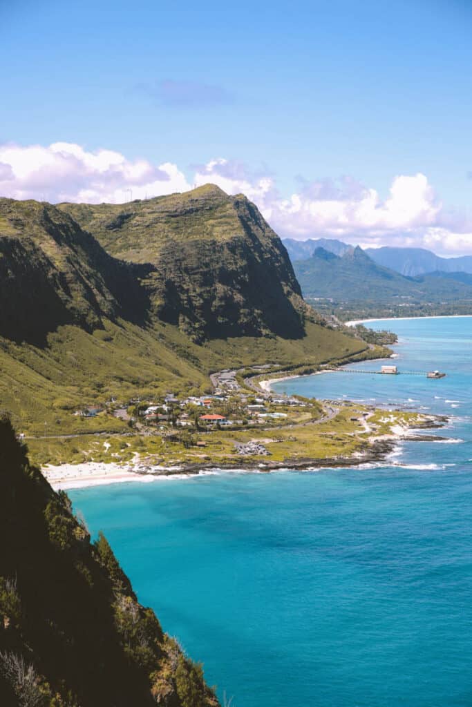
The Makapuʻu Lighthouse Trail is the second most popular hike on all of Oahu, just behind Diamond Head. It follows a paved road — once the access route for lighthouse keepers — that winds up the western face of the ridge before curving north and ascending to the summit. The trail gains 500 feet in about a mile, entirely exposed to sun and wind.
There are four viewpoint pullouts on the way up, each with informational panels about the lighthouse history, wildlife, and geology. The first viewpoint at the half-mile mark already delivers views of Koko Head Crater and the Ka Iwi Coastline behind you. The summit platform, at the trail's end, offers a full 360-degree panorama: Makapuʻu Beach and Rabbit Island below you, the windward coast of Oahu sweeping north, Molokai visible across the channel on clear days, and the lighthouse perched dramatically on the cliff below.
⚠️ Trail hours: Opens 7:00am daily. Closes 6:45pm (winter, after Labor Day) or 7:45pm (summer, April 1st onward). No reservation or fee required — ever. The trail is fully paved and dog-friendly on leash. There are no restrooms at the trailhead — use facilities at Makapuʻu Beach Park nearby before you start. No water refill stations either — bring your own.
Wildlife: Whales, Seabirds & Tide Pools
Makapuʻu is one of the premier whale-watching locations on all of Oahu. Between November and May, North Pacific humpback whales migrate to Hawaiian waters to breed and give birth, and the elevated views from the Makapuʻu trail put you 500 feet above sea level — the perfect vantage point to watch them breach, spout, and surface in the channel below. The viewing platforms have mounted binoculars, and peak season is January through March.
Offshore, the egg-shaped Mānana Island (commonly called Rabbit Island) floats just south of the trail's summit view. The island is a protected seabird sanctuary for wedge-tailed shearwaters and other native birds — landing is prohibited, but the view from above is spectacular. Its rabbit-eared profile is one of the most photographed silhouettes in all of Oahu.
The Secret Tide Pools
About halfway up the trail, an unmarked path branches down the hillside to Makapuʻu's famous tide pools — two large ocean-filled pools carved into the ancient lava shelf, brilliant turquoise-green against the black rock. The pools are a popular spot for a post-hike soak, but the route down is rocky and unmaintained. This side trip is suited to fit, experienced hikers only — rogue waves have proven deadly here, and conditions change rapidly. Never visit the tide pools in high surf.
Getting There
The trailhead parking lot is located off Kalanianaole Highway (Hwy 72) at the southeastern tip of Oahu, approximately 16 miles (25 minutes) from Waikiki. Coming from Honolulu, drive east on H-1 until it becomes Hwy 72, then continue past Hawaii Kai, Hanauma Bay, and Sandy Beach. The parking lot entrance is on the left, just south of the Makapuʻu Lookout. From Kailua on the windward side, it's about 10 miles south on Hwy 72.
Satellite Map
Movies & TV Shows at Makapuʻu
The dramatic cliffs, the lighthouse, the crashing surf, and the otherworldly silhouette of Rabbit Island have made Makapuʻu one of East Oahu's most-used filming locations. From a 1980s private detective to a 2000s island mystery to an Adam Sandler rom-com, this corner of Oahu has been on screens for over four decades.
The original Magnum P.I. used the Makai Research Pier at Makapuʻu Point as the real-world location for TC's "Island Hoppers" helicopter base — the fictional operation where Thomas Magnum's friend Theodore "TC" Calvin ran his helicopter charter service. The pier appears throughout the series' eight-season run, and the Makapuʻu coastline served as a regular backdrop for the show's aerial and chase sequences. When Tom Selleck's Ferrari wasn't speeding down a coastal highway, the Makapuʻu cliffs were often providing the dramatic scenery.
ABC's legendary survival drama — which filmed almost entirely on Oahu for six seasons — used the Makapuʻu Lighthouse Trail as a confirmed filming location. The rugged, isolated character of the trail, with its volcanic cliffs and sparse vegetation, made it an ideal stand-in for the mysterious island's more forbidding terrain. The show, which ran from 2004 to 2010 and became one of the most-watched dramas in television history, filmed at dozens of Oahu locations from Kualoa Ranch to Makapuʻu's eastern cliffs.
The hit romantic comedy filmed extensively across East Oahu — and the Makapuʻu Lighthouse is one of the confirmed filming locations. More notably, the movie used Sea Life Park, located directly below the Makapuʻu trail at the base of the cliffs, as the real-world location for the marine park where Adam Sandler's character Henry Roth works as a walrus trainer. Visitors on the Makapuʻu trail today can look down and spot Sea Life Park in the cove below — the same spot where Henry first meets Lucy.
CBS's decade-long reboot of the classic detective series filmed all 240 episodes on Oahu, with Makapuʻu's beach, cliffs, lighthouse, and the Makai Research Pier appearing across multiple seasons. The pier alone appeared in over a dozen episodes. The series also referenced Makapuʻu directly — the Season 2 episode "Three Dead Cows at Makapuʻu" used the beach below the lighthouse for its key scene. The show ran for 10 seasons and did more to promote Oahu tourism in the 2010s than almost any other production.
From Tom Selleck's helicopter landings to a castaways' scramble through volcanic terrain, Makapuʻu has quietly accumulated one of the most impressive film résumés of any location in Hawaii — spanning five decades without ever asking for top billing.
Insider Tips for the Best Hike
🥾 Pro Tips from Our Guides
- 🌅Come for sunrise or the annual First Day Hike — Every January 1st, hundreds of locals hike Makapuʻu in the dark to reach the summit for the first sunrise of the New Year. It's a moving, spiritual experience — but even on a regular morning, arriving just after 7am means golden light, cool temperatures, and almost no crowds.
- 🐋December through March is whale season — Humpback whales migrate through the Kaiwi Channel right below the trail. Bring binoculars (or use the ones mounted at the viewpoints). January and February are peak sighting months. A whale breaching 200 feet below you is something you'll never forget.
- 🧢There is zero shade on this trail — The entire path is exposed volcanic ridge. Start before 9am or after 4pm to avoid the punishing midday heat. A wide-brim hat is essential — it's also very windy at the summit, so bring a hat clip or strap.
- 💧Bring more water than you think you need — At least 32oz per person (1 liter) for the 2-mile round trip. There are no water fountains anywhere on the trail or at the trailhead. The heat and wind will dehydrate you faster than you expect.
- 🅿️Parking fills up fast on weekends — The lot holds about 30 cars. Arrive by 7:30am on weekends or you'll be parallel parking along Hwy 72. Weekday mornings are much easier. As a HI Private Tours client, we time our arrival perfectly — no parking stress.
- 🌊Don't attempt the tide pools in any swell — The unofficial trail down to the tide pools is steep, loose, and not maintained. Rogue waves have swept people off the lava shelf. Check surf conditions at Windguru or Surfline before considering this detour — and never go alone.
- 👟Any shoes work — it's completely paved — You don't need hiking boots. Comfortable sneakers, running shoes, or even sandals are fine. The surface is smooth asphalt the entire way. We've seen strollers and wheelchairs make it to the first viewpoint.
- 🔭On a clear day, you can see four islands — Molokaʻi is almost always visible to the east. Lanaʻi and Maui appear on very clear mornings. Asking your guide to point them out is one of those magical tour moments.